10 Years Experience
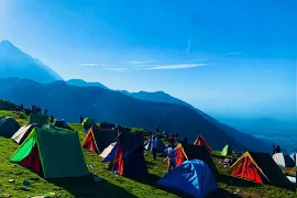
Specialized in Triund Camping

Dharamkot Road
Near Gandhi's Paradise
700 Meters from Main Square
Mcleodganj, Himachal Pradesh
Here's a detailed overview of the Mullayanagiri Trek presented in bullet points:
Weather: The weather around Mullayanagiri varies with the seasons. Summers are pleasant with temperatures ranging from 15°C to 25°C. Monsoons, from June to September, bring heavy rainfall. Winters are cool with temperatures dropping to around 10°C or lower.
How to Reach: The trek to Mullayanagiri usually starts from the town of Chikmagalur in Karnataka, India. Chikmagalur is accessible by road from major cities like Bangalore and Mangalore.
Distance: The total trekking distance to Mullayanagiri and back is approximately 8 kilometers, depending on the specific route taken.
Location: Mullayanagiri is located in the Chandra Dhrona Hill Ranges of the Western Ghats in Karnataka, India.
Peaks: Mullayanagiri is the highest peak in Karnataka, standing at an altitude of 1,930 meters (6,330 feet) above sea level.
Difficulty: The Mullayanagiri Trek is considered easy to moderate in difficulty, with well-defined paths and gradual ascents.
Duration: The trek typically takes around 3-4 hours to ascend to the summit and 2-3 hours to descend back to the base, depending on the trekker's pace and rest stops.